


PEI·New
A monthly update of the Canadian Drought Monitor shows many parts of the Atlantic region in the red, representing ‘extreme drought,’ including almost the entire province of Prince Edward Island.
The federal government updates its Canadian Drought Monitor once a month

Carolyn Ryan · CBC News
· Posted: Sep 12, 2025 2:19 PM EDT | Last Updated: 25 minutes ago
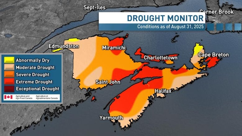
Canadian Drought Monitor data as of Aug. 31 shows much of the Atlantic region either red for extreme drought or shades of orange for moderate to severe drought. (Jay Scotland/CBC)
A monthly update of the Canadian Drought Monitor shows many parts of the Atlantic region in the red, representing “extreme drought,” including almost the entire province of Prince Edward Island.
Agriculture and Agri-Food Canada posted the updated map, based on data from Aug. 31, this week.
As for the Atlantic region, only parts of Labrador showed normal conditions, with areas on the island of Newfoundland ranging from “abnormally dry” to “exceptional drought,” especially on parts of the Avalon Peninsula stricken by forest fires this summer.
Most of New Brunswick and Nova Scotia ranged from “moderate drought” to “severe drought” conditions.
“At the end of the month, 72 per cent of the Atlantic Region was classified as abnormally dry (D0) or in moderate to extreme drought (D1 to D3), including 100 per cent of the region’s agricultural landscape,” text accompanying the map said.
This story was brought to Nouzie by RSS. The original post can be found on https://www.cbc.ca/news/canada/prince-edward-island/pei-rainfall-drought-agriculture-canada-map-1.7632465?cmp=rss
